
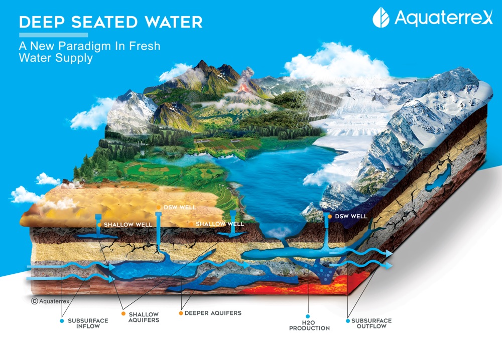
Fig. 01 — Both sources in one cross-section. The shallow aquifer depletes; primary water does not.
Certified engineers using precision instruments to locate underground water — shallow aquifers and deep-seated primary water alike — streams, water-bearing rock, depth, and yield, before you spend a single rupee on a borewell.
There are two kinds of water beneath your land. Shallow aquifers, recharged by rainfall and monsoon, depleting in dry years. And deep-seated primary water — trapped in fractured rock beneath the impermeable layer, independent of the monsoon. Our instruments capture both. We are certified engineers based in Pune. We instrument. We measure. We verify. And we give you the best coordinates to drill.
Your land may hold two kinds of water. A shallow aquifer, recharged by rainfall and monsoon, sitting above the impermeable rock layer. And deep-seated primary water, trapped in fractured rock beneath it, independent of rainfall. Our instruments capture both — and we tell you which one to drill for, where, and how deep.
Drilling a borewell in India costs between ₹2,00,000 and ₹8,00,000 — and in hard-rock Maharashtra, the failure rate is brutal. Our process exists to make sure the point we mark is the right one. Nine steps. Every step uses instrument-derived data, for both shallow aquifers and deep-seated primary water.
We map the underground water stream and the direction in which it flows across your land. A stream is not a single point — it is a moving body, and drilling upstream vs downstream changes everything.
We run targeted scans over the stream axis to find which stretches yield maximum water at the lowest depth. Depth matters — shallower hits are cheaper to drill and easier to lift from.
We locate the exact spot where water-bearing fractured rock sits beneath the surface — whether a shallow aquifer above the impermeable layer or a deeper primary water source below it. Not the general area. The exact spot.
Using instrument-derived reports, we identify the depth of each water source. Multiple water-bearing layers can exist at the same XY spot at different depths — a shallow aquifer at 200 ft, a primary water layer at 800 ft — and we mark each one.
Depth alone is useless without yield. We use the same instrument reports to estimate the water quantum — litres per minute — so you know before drilling whether this borewell will fill your overhead tank in 20 minutes or 4 hours.
We confirm the geological reports against physical factors: rock hardness, rock permeability, hardness gradients across layers, and soil conductivity. A layer that reads "water-bearing" but is impermeable will not yield. We check.
The goal of the entire process: find the point where the borewell hits maximum water at minimum depth. Drilling deeper costs ₹400-₹800 per foot in Maharashtra. We optimise for the total cost of the borewell, not just "hitting water" at any depth.
Most of our calls come from plots where two, three, four borewells have already been drilled dry. We survey for whatever source your land still holds — an untapped shallow aquifer the previous borers missed, or a deeper primary water source they never reached.
A stream fracture may be 3 feet wide. Mark two feet to its left and the drill passes through solid basalt — and you spend ₹4 lakh on dust. We attempt to find the best point so that no money is wasted on dry wells. Precision is the entire service.
That is not a marketing line — that is the geometry of fractured-rock aquifers. A water-bearing fissure can be narrower than a doorway. We attempt to find the best point with the best information available. Every step of our process exists to make sure the borewell rig arrives at the right X, the right Y, and drills to the right Z.
Every survey we complete is documented on video at the drilling site — coordinates, depth hit, yield observed. These are not rendered simulations. They are farmers, plot-owners, and institutions who let us try after others had declared the land dry.
Water found at 200 ft.
Water found at 680 ft.
Water found at 615 ft.
Water found within 150–250 ft.
Water found within 150–250 ft.
Water found within 150–250 ft.
Primary water is not fringe theory. It is documented in peer-reviewed geology, in news reports from mainstream outlets, and in the published work of researchers at Northwestern University, the University of Alberta, and others. A curated archive of these reports is maintained at desertstoforests.org.
"A reservoir of water three times the volume of all the oceans has been discovered deep beneath the Earth's surface."
Researchers analysing a diamond from Brazil found ringwoodite — a mineral that holds water — at 660 km depth. The finding confirmed vast deep-seated water reserves. Cited via desertstoforests.org media archive.
"The water is inside a rock called ringwoodite, and it acts like a sponge — holding water deep within Earth's mantle transition zone."
Steve Jacobsen, geophysicist at Northwestern, lead researcher on the 2014 ringwoodite study. His team confirmed that the deep-seated water is not liquid — it is bound in the mineral structure of mantle rock, released under pressure through fissures.
"This is a clear indication that the Earth's water cycle includes the deep interior — there are oceans of water trapped in rock."
Coverage of the ringwoodite discovery, summarised in the desertstoforests.org media section. The discovery reframed groundwater science: the deep-seated water budget is orders of magnitude larger than all surface water combined.
"Primary water is the original water of the Earth — trapped in rock at the time of the planet's formation, forced upward through fissures under lithostatic pressure."
The Primary Water Institute maintains a research library at primarywaterinstitute.org, documenting historic deep-seated water wells — including flows in arid regions where rainfall could not account for yield.
We are a small group of environmental enthusiasts who watched the water and drought situation across India get worse — year after year, monsoon after failed monsoon — and decided to find a permanent solution to it. We are all certified engineers. We understand the science behind water — the geophysics, the rock mechanics, the instrumentation — more rigorously than many in this field. We are based in Yerwada, Pune.
Call us before the rig arrives. We will travel to your land, run the survey, and deliver a written report with the drilling coordinates, recommended depth, and expected yield. Serving Maharashtra, Gujarat, and Jammu & Kashmir.